It’s about a thousand miles to drive on Highway 1 from San Francisco to Port Angeles, the northern-most town that connects the US and Canada. The drive along the ocean is beautiful, through vast coastal landscapes and ancient forests. One can find some of the tallest and oldest trees in the world along this remote coastline, small fishing towns, Indian reservations, and several world-famous National Parks. I travelled the whole distance during this summer, and I want to share some of the pictures below. Links to more extensive photo pages are at the bottom.
About the Region
The Pacific North West includes Northern California, Oregon, Washington State, and the Canadian province of British Columbia. It is sparsely populated, mountainous, and represents the edge of the American Continental plate – further inland is a string of massive volcanic mountains: Mount Rainier, Mount Hood, Mount St.Helens, and Mount Shasta. The region has about 8 million inhabitants, and the main urban centers are Vancouver, Seattle, and Portland, all situated along Highway 5.
The Pacific Northwest has a wide variety of climates. A typical oceanic climate (mild, humid, and warm) can be found in most coastal areas, between the ocean and high mountain ranges. An Alpine climate dominates in the high mountains. Semi-arid climates are found east of the higher mountains, especially in rain-shadow areas. Humid continental climates occur inland on windward locations.
The region has been occupied by a diverse array of Native Americans for the last 14,000 to 15,000 years. The Pacific Coast seems to have been a major migration route for people from northeast Asia, who travelled through Siberia into the Americas. Due to the richness of the Pacific Northwest Coast and its rivers and forests, the indigenous groups developed complex and diverse hunter-gatherer societies.
The first European who sailed up the West Coast in 1579 was the British captain Sir Francis Drake. During the early 1740s, Imperial Russia sent ships into the region, and by the late 18th century, Russia had established several posts and communities along the Coast. The “Russian River” in Northern California still carries the memory of these settlers. Spain also sent expeditions who found the Olympic Peninsula near the mouth of the Quinault River, and they also discovered the mouth of the Columbia River in 1775. The region was systematically charted by George Vancouver on behalf of Great Britain from 1792 to 1794. One of the early travelers remarked about the native culture they found: “What must astonish most is to see painting everywhere, everywhere sculpture, among a nation of hunters”. In 1804, US President Jefferson sent an expedition to explore a landroute through the continent, after the Louisiana Purchase of this land in 1803. The Lewis and Clark Expedition started from the East Coast and reached the Pacific Ocean at the mouth of the Columbia River in 1805.
The region is economically very prosperous: Agriculture, forestry, fishing, mining, Aerospace (Boeing), Technology (Microsoft, Amazon, Intel, Expedia), and retail (Costco, Starbucks.)
Redwood Forests along the California Coast
Driving north from Fort Bragg towards Eureka and Crescent City will lead you to some of the most amazing forests in the world: Humboldt Redwood State Park with it’s Avenue of the Giants, the huge territories of Shasta Trinity National Forest, Six Rivers National Forest, and Klamath National Forest, as well as the Redwood National Forest closer to the Ocean.
Coast Redwoods, or Sequoia Sempervirens, only grow in the cool and moist climate along the California coast, between the Oregon Border and Big Sur. The parks mentioned above protect these trees, and some of them are the oldest and tallest trees on earth. The temperate climate, abundant winter rain, and summer fog make this area ideal for coastal rainforests. Coast Redwoods are different from Giant Sequoias, which are shorter, bulkier, and more massive, and can only be found in the western Sierra Nevada mountain range, for instance in Yosemite. The third type of redwood, the Dawn redwood, is native to central China and is considered to be the closest relative of the coast redwood. Redwoods have been around for about 240 million years, and in California for at least 20 million years.
Coast redwoods are the tallest known tree species in the world. Mature trees average 150 – 250 feet, and some of the tallest trees exceed 350 feet (over 100 meters) with a diameter of 12-20 feet. They grow on alluvial plains, which are low-lying river plains with nutrient-rich soil composed of decaying plant material. These trees are very resilient: They often live several hundred years, and in some cases, more than 2,000 years. This makes them one of the longest-living species in the world. Resistance to fire and disease enables them to have very long lifespans. Coast redwood tree-bark is often over a foot thick, and creates a formidable barrier against diseases. The high tannin content of the bark repels insects, while the low amounts of resin resist fire. Although they have a strong defense against disease and fire, redwoods are susceptible to high winds and flooding, because unlike most trees, redwoods have no taproot. Instead, they have a shallow root system that reaches only about 12 feet underground, but extends up to 100 hundred feet outward, which forms a network of connected root systems with other trees. Despite the connected roots, high winds and/or flooding can bring these massive trees to the ground. Coast Redwoods are conifers – they are woody and produce seeds in cones. The cones are very small, only about 1 inch long, and each cone contains many seeds. Few of the seeds will germinate, so redwoods also sprout new trees from the root of a parent tree or from burls around the base of the stem, which contain thousands of dormant buds. Due to this form of growth, redwoods form circles and dense groves. When you walk into one of these groves, you enter another space – the air and humidity changes, it gets quiet, and you enter deep shadow or twilight – sometimes people think they enter the interior of a church.
Here are some photos, and here is a link to the larger collection.
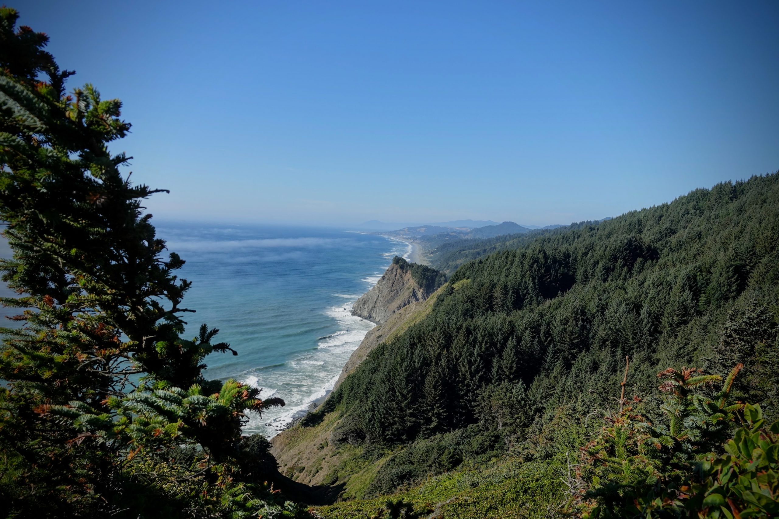
Oregon Coast
Oregon has 360 miles of coastline between Astoria in the north and Crescent City on the California side in the south. This is one of the most spectacular drives in the US during the summer months, when it is not raining: small towns, hidden white-sand beaches, sand dunes, lighthouses, and small harbors. The colors, lights, and smells are incredible. The ocean ranges from steely-grey to green-blue luminous colors; and the sunsets are unforgettable. Occasionally a group of whales cruises along the beach, and I was lucky enough to watch them for a while.
The Shore Acres State Park has one of the most classy rose gardens I ever saw. If you are interested in food, the Restaurant Beck in Depoe Bay (inside the Whale Cove Inn) is definitely worth a visit. They use ingredients from local producers and create an award-winning dining experience. And then, there is of course the Tillamook cheese factory, the place where cheddar cheese was invented. Here is a selection of photos, and here is the photo page.
Olympic National Park
Even among National Parks, the Olympic National Park is a category on it’s own. It is located on the Olympic Peninsula in Washington State, and has a unique collection of landscapes. If you walked from the ocean inland, across Olympic National Park, you would start at the rocky Pacific shoreline with unforgettable beaches, move into rare temperate rainforests and lush river valleys, climb up glaciers and rugged mountain peaks, and then descend into a comparatively dry rain-shadow alpine forest. The highest peak, the snow-covered Mount Olympus, rises to 7980 feet (2430 meters). The park encompasses nearly 923,000 acres of wild lands, which includes 366,000 acres of old-growth forests (572 square miles or 1480 square kilometers). The park also includes 60 named glaciers, 73 miles of coast, and 3,000 miles of rivers and streams. The park includes more than 1,200 native plant species and hundreds of fish, mammal, and animal species. The Olympic National park shelters at least 22 species listed as threatened or endangered under the Endangered Species Act. It has over 3 million visitors annually.
The area that forms the park today has a long human history: 650 archaeological sites document more than 12,000 years of Native American and European settler history. A rich culture existed long before European and American explorers and settlers arrived. As we all know, their impact on these indigenous cultures was overwhelmingly negative, mostly because the newcomers brought devastating diseases with them. The University of Washington maintains a web-based museum that showcases the rich history and culture of Washington State’s Olympic Peninsula original communities.
The Olympic National Park started out as the “Olympic Forest Reserve”, designated by President Grover Cleveland in 1897. It became the Olympic National Forest in 1907. This evolved into Mount Olympus National Monument under President Theodore Roosevelt in 1909, and finally became a National Park in 1938. The area was declared an International Biosphere Reserve in 1976, and became a United Nations World Heritage Site in 1981.
The park contains a very unusual ecosystem between the coast range and the Olympic Mountain range – temperate rainforests. The Olympic National Park is one of the few places in the world with this unique landscape. 150 to 180 inches (380 to 450 centimeters) of rain fall on coniferous and deciduous forests each year, as warm, moist air from the Pacific Ocean moves inland over the cool, rising landscape, and drops rain, snow, and mist most days of the year. As opposed to tropical rainforests, the rainforests of the Pacific Northwest consist of trees like the Sitka Spruce, Western Hemlock, Coast Douglas-fir and Western redcedar. Due to the constant rain and moisture, a variety of mosses grow on the bark of these trees and flow down from their branches in green, moist tendrils. The forest floor is covered with lichens, mosses, and ferns. Three glacial rivers – the Hoh, Queets, and the Quinault – flow westward from the mountains through these forests, which extend almost to the coast. The Olympic National Park also includes a part of the coastline. Kalaloch and Ruby Beach are spectacular, they overlook a coastal area that is a vast marine sanctuary.
Miscellaneous Facts:
- In 2011 and 2012, two dams were finally removed again from the Elwha River to restore the ecosystem. This dam removal allowed Pacific salmon to access another 60 miles of river, and swim upstream to return to their breeding grounds. The river’s natural sediment can again flow downstream to rebuild the beaches at the river’s mouth.
- Northwest Washington saw its lowest snow cover on record in the spring of 2015.
- Considering that the Hoh Rain Forest receives 12 feet of rain annually, it might seem impossible for the area to catch on fire. However, 2015 was one of the hottest years on record, and therefore an unusual year for precipitation. Due to the minimal snowpack from the previous winter, and the driest spring in over a century, Olympic was more susceptible to fire than ever. A lightning strike in the drought-stricken forest resulted in what became known as the Paradise Fire, which burned from the beginning of June through September of 2015.
- Link to photo page.
Seattle and Portland
The Pacific Northwest is a rapidly growing region. The two largest urban centers are Seattle and Portland. Seattle has about 685,000 residents as of 2015, and is the largest city in the Pacific Northwest region of North America. It is also one of the fastest-growing cities in the United States with an annual growth rate of 2.1%. The larger Seattle metropolitan area has over 3.7 million people. It is the third-largest container port in the US as of 2015, and functions as a major gateway for the trade with Asia.
The first industry for Seattle was logging, and during the 19th century, it became a commercial and shipbuilding center, and the gateway to Alaska during the Klondike Gold Rush. By 1910, Seattle was one of the 25 largest cities in the US. The Great Depression in the 1930s severely damaged the city’s economy, until World War II brought another economic boom. Seattle is home to the airplane manufacturer Boeing, and eventually, the Seattle area developed as a technology center beginning in the 1980s, with companies like Microsoft and Amazon. This led to an economic revival and fuels continuing population increase.
Portland is similar in size to Seattle with a population of 633,000 people in 2015. The larger Portland area houses approximately 2.4 million people. Portland began to grow in the 1830s, because the Oregon Trail,which brought people to the West, ended in this area. The Columbia River flows through Portland and connects the city to the Ocean, 80 miles downstream in Astoria. The river has a length of 1240 miles, so it opens up the Pacific Northwest and its vast interior areas. It also has major tributaries, like the Snake river, and a huge drainage basin. It originates in Alberta, Canada, and for hundreds of miles it flows south, before turning west towards the Ocean. This river system provides convenient transportation of goods, and is also used for the generation of hydroelectric power. 14 dams along the main river produce about 40% of the total hydroelectric power of the US.
The early industry of the area was dominated by the timber industry. At the turn of the 20th century, Portland had developed a reputation as one of the more dangerous port cities in the world, a hub for organized crime. But World War II brought an economic boom, and the bad reputation began to dissipate. Portland slowly developed into a city known for its liberal political values, and as a bastion of counterculture. When I walked through Portland it felt like being in Berkeley. Both cities share a love for coffee shops and book stores: Portland is home to the famous Powell Book Store, which extends through a whole city block, and claims to be the largest independent book store in the world. It’s definitely worth a visit!
Portland frequently ranks as one of the best cities to live in, and is recognized as one of the most environmentally conscious cities in the world. It has a well-developed public transportation system, and it is easy to walk or bike through it. It also has many innovative restaurants that are connected to local farms and farmer markets – they focus on organic food and sustainable farming practices. One restaurant that stands out and deserves to be recommended is Le Pigeon, a French Restaurant run by a young chef trained in Napa.
Portland also has over 10,000 acres of public parks, and several beautiful gardens (see my next entry, Pacific Gardens.) It has warm, dry summers, and cold, rainy winters, which makes it ideal for growing roses. Portland houses the International Rose Test Garden, and has been called the “City of Roses” for over a century.
Mount Rainier and Mount Shasta
These two volcano mountains belong to the so-called Cascade mountain range, a north-south mountain range that marks the edge of a tectonic plate. The Cascades are part of the Pacific Ocean’s Ring of Fire, a ring of volcanoes and associated mountains around the Pacific Ocean. All of the eruptions in the contiguous United States over the last 200 years have been from Cascade volcanoes.[ref]The two most recent were Lassen Peak from 1914 to 1921 and a major eruption of Mount St. Helens in 1980.[/ref].
Mount Rainier is the highest mountain in the Cascade Range, with 14,411 feet (4392 meters). It is almost twice as high as Mount Olympus on the Olympic Peninsula. There is a volcanic crater on the summit, and the summit is surrounded by 26 glaciers, which create 36 square miles (93 km2) of permanent snowfields and ice.
This heavily glaciated peak poses a great danger if Mt. Rainier were to erupt as powerfully as Mount St. Helens did in 1980. Mt Rainier is a much bigger volcano, almost twice the size of St. Helens. There is a massive amount of glacial ice on the mountain, and the Seattle Metropolitan Area is only 55 miles away. The mountain poses a clear danger for the people living in its vicinity, and as a precaution, the United States Geological Survey installed an early warning system in 1998.
The landscape on the slopes of Mount Rainier is spectacular, to say the least: On March 2, 1899, US President William McKinley established Mount Rainier National Park as America’s fifth national park. It is a huge and rugged nature reserve with streams, waterfalls, valleys, rocks and enormous boulders, all embedded into ancient forests. See some pictures below.
Mount Shasta belongs to the same mountain range and lies 500 miles south of Mount Rainier. It is also a potentially active volcano and belongs to the Shasta-Trinity National Forest. It has an elevation of 14,179 feet (4321 m). Mount Shasta really consists of four overlapping volcanic cones, which creates a huge volcanic system with a gigantic volume of 85 cubic miles (350 km3). The volcano is pretty active, and will eventually erupt again: during the last 10,000 years, Mount Shasta has erupted on average every 800 years, but in the past 4,500 years, the volcano has erupted on average every 600 years. The last significant eruption occurred about 200 years ago.
The human history of the mountain and its environment reaches far back in time: The oldest known human habitation in the area dates to about 7,000 years ago, and by about 5,000 years ago, there were substantial human settlements in the surrounding area. Europeans and Americans arrived in the 1820s and found many Native American tribes who lived within view of Mount Shasta.[ref] This included the Shasta, Okwanuchu, Modoc, Achomawi, Atsugewi, Karuk, Klamath, Wintu, and Yana tribes.[/ref]
More than any other mountain, Mount Shasta inspires spiritual sentiments and religious feelings. It is an integral part of Native American mythologies, and rituals are still performed on the mountain today. It is considered to be a sacred entity.[ref]The Klamath Tribe, for example, believes that Mount Shasta is inhabited by the Spirit of the Above-World, Skell, who descended from heaven to the mountain’s summit at the request of a Klamath chief. Skell fights with the Spirit of the Below-World, Llao, and this explains the volcanic eruptions.[/ref] Extensive ethnographic research has been done; it shows for instance that practitioners searched for power and sacred energy on the mountain in order to acquire the skills necessary to serve as shamans in the medical and religious aspects of Native American life. A candidate would visit a sacred place and invoke the spirits associated with it. This is done through prayers and rituals. Caves, springs, meadows, and rock formations are the settings for these initiations.
The mountain is also significant for other spiritual traditions and New-Age world views. You will find a Buddhist monastery (Shasta Abbey, founded in 1971,) and the town of Mount Shasta has stores that offer crystals, stones, herbs, statues, books, and other spiritual paraphernalia. Mount Shasta has been the focus of non-Native American legends as well. One persistent legend, for instance, claims that somewhere on the mountain there is a hidden city of advanced beings from the lost continent of Lemuria. Some New-Age adherents believe that Mount Shasta is an energy vortex, a global power center that has not only spiritual significance for individuals but influences the cosmic vibration of the earth as a whole.
It’s easy to dismiss these claims, but I recommend you go in person to experience the mountain and feel its energy – chances are that you will have a profound experience of some sort. In the end, words fall short in describing these landscapes and mountains. The reality is different, and it is transformative.